
EFDL
Extreme Floods on the Lower Danube:
Leveraging Hydroclimate Reconstructions to Address Future Hazards
EFDL
Inundații extreme în bazinul inferior al Dunării: valorificarea reconstrucțiilor hidroclimatului pentru a aborda pericolele viitoare.
Proiect Nr. Unitatea Executivă pentru Finanțarea Învățământului Superior, a Cercetării, Dezvoltării și Inovării (UEFISCDI)
Manager de proiect: Florin Filip
REZUMAT
|
Sistemul fluvial al Dunarii de Jos este foarte important pentru economia Romaniei, fiind folosit pentru hidroenergie, agricultura si comert. Inundatii extreme au afectat acest sistem fluivial cu efecte asupra infrastructurii, oamenilor si economiei. Infrastructura de protectie impotriva inundatiilor a fost testat sever in ultimul secol. Conditiile hidroclimatice viitoare insa, sunt preconizate a fi chiar mai severe in intensitate si frecventa. Cea mai importanta intrebare in acest caz este susceptibilitatea inundatiilor la schimbarile climatice. Cum va putea supravietui sistemul existent de protectie impotriva inundatiilor la aceste schimbari majore? |
D1. Issues
There will be justified the scientific motivation of the project theme by delimiting the issue addressed in the context of the state of the art in the scientific field. There will be highlighted the following three issues: (1) the importance of the issue from scientific, socio-economic or cultural point of view; (2) the elements of difficulty of the issue; (3) the limitations of current approaches by analyzing the state of the art of the knowledge related to the project topic.
The Danube River system is an economic pillar of the Romania, used to generate hydroelectric power upstream, providing fertile agricultural soils within its floodplain, and a major gateway for trade and commerce near its mouth and Danube-Black Sea channel. Large floods over the last century have proven costly along the Danube and its main tributaries – both in economic and social terms – damaging infrastructure, disrupting trade, and displacing people. In response, Romanian authorities implemented flood protection projects along the system [Constantinescu et al., 2015]. This flood control infrastructure was severely tested by several high magnitude events over the 20th century and future hydroclimatic conditions are likely to surpass these in magnitude and frequency [Milly et al. 2002; Field et al. 2012; Kundzewicz et al. 2014]. One important question, given the sensitivity of flood frequency and magnitude to climatic change, is whether the current system of flood control along the lower Danube will be able to contain the river over the next century?
Climate is the main driving force of hydrological systems, and large floods on the lower Danube are generated by episodes of intensive and prolonged precipitation over the drainage basins of major tributaries [Sommerwerk et al., 2009; Glasser et al., 2010; Hattermann et al., 2018]. Depending on the severity of climate change, the risk of extreme events are projected to increase drastically between 10 and 30% over the next century [Bisselink et al., 2018], surpassing effects of land use and water usage. Yet, it remains poorly understood how these projected hydrological changes will alter flood frequency and magnitude on large rivers like the Danube [IPCC, 2013], in part because instrumental discharge records are short, typically spanning less than 150 years, and capture a limited range of hydroclimatic variability [Lubchenco & Karl, 2012; Paasche & Støren, 2014].
The location, duration, and intensity of precipitation over the Danube basin in central and eastern Europe has been linked to major modes of climatic variability – including the the North Atlantic Oscillation (NAO) and El Nino-Southern Oscillation (ENSO) – that control the flux of moisture into central and eastern Europe [Rimbu et al., 2004]. Understanding how such major modes of climatic variability interact with regional hydrology to generate high-magnitude floods would improve predictions of how the Danube River will behave in the future, but relatively few extreme flood events are available for study in the short instrumental record.
River engineering efforts over the last century has transformed the Danube River system, markedly altering the behavior of the river independently of climatic variability [Constantinescu et al.,
2015]. Upstream dams have dramatically reduced sediment loads and changed the relationship between discharge and flood stage [Panin and Jipa, 2002; Habersack et al., 2016]. Because much of the instrumental record overlaps with human efforts to manage the river, it is often challenging to document the response of fluvial systems to climatic variability from instrumental records alone [e.g., Villarini et al. 2009].
To overcome the challenges associated with short instrumental records, a new generation of paleoflood records is rapidly emerging that uses the sedimentary archives held in floodplain lakes to extend flood records back centuries to millennia [Paasche & Støren, 2014]. New developments in paleoflood hydrology show that oxbow lake sediments are suitable for reconstructing both the frequency of extreme floods as well as their magnitude [Glur et al. 2013; Toonen et al. 2016; Munoz et al. 2018]. Despite the suitability of this method to extend the record of Danube River floods back centuries to millennia, such paleoflood records are still not available.
In short, there is a critical need to understand how large river systems like the Danube respond to a broader range of hydroclimatic variability. Research proposed herein uses a relatively novel approach in paleoflood hydrology– the use of sedimentary records held in floodplain lakes – to develop new records of flood frequency, magnitude, and provenance for the lower Danube River over the last millennium. These paleoflood records will serve to extend the short instrumental flood record by centuries and improve our understanding of how major modes of climatic variability interact with the hydrological system, two problems that are vital to address future hazards along the lower Danube valley.
D2. Objectives
There will be presented the project approach in principle, highlighting the following two aspects: (1) the specific objectives of the project; (2) the elements of originality and innovation that the implementation of the objectives brings to the field, in relation to the state of the art of the knowledge and related to projects where the applicant was involved (if the case);
The mentor for this project is a global leader in paleohydrological reconstructions (see Munoz et al., 2018; Munoz et al., 2019) and original methods developed by his team will be employed in the current study.
Research Questions:
Question A How has the frequency of extreme floods on the lower Danube River varied over the last millennium? How are periods of more frequent high-magnitude floods associated with atmospheric circulation patterns over the North Atlantic and global patterns typical for ENSO?
Question B How have the spatial patterns of flooding on the lower Danube River basin expressed along tributaries and varied over the last millennium?
Objectives:
- Develop paleoflood chronologies from the lower Danube.
- Reconstruct paleoflood magnitudes and uncertainties for the lower Danube River and its major tributaries over the last millennium.
- Build a dataset of early 20th century strontium, neodymium, and lead isotopic signatures of floodplain sediments for the major tributaries of the Danube River system.
- Characterize shifts in the provenance of high-magnitude flood events on the lower Danube River over the last millennium.
D3. Impact
There will be discussed the aspects related to the potential impact of the project in the broader frame of the scientific field, with emphasis on the following aspects: (1) the potential to significantly influence the
scientific field through new concepts or approaches, and if necessary, by opening of new themes or research directions; (2) discussing the potential impact of the project in the scientific, social, economic or cultural environment and/or the applicative directions to be explored within the project (where applicable for the proposed research direction);
I propose to develop and analyse unique paleoflood records that offer a novel opportunity to understand hydrological variability in the Danube River basin during the late Holocene. The proposed research will provide comprehensive paleoclimate data sets that can serve as model test data sets analogous to instrumental observations, in order to understand the response of the long-term and higher magnitude variability of the climate system. Data produced through this project will help to develop spatial-temporal networks needed to will help address regional hydrologic variability (e.g., droughts and floods) in Europe, identify how regional climates, including temperature, precipitation-evaporation, climate modes, and extreme climate events (e.g., drought, floods, tropical storms), varied and interacted on seasonal to longer time scales.
The proposed project will deliver a long-term, quantitative reconstruction of flood frequency, magnitude, and provenance spanning the last millennium in an area where available instrumental records are relatively short and often discontinuous. Our reconstruction will be used to examine how different modes of climatic variability interact to produce extreme floods events, and will improve our understanding of how major river systems will respond to the novel hydroclimatic conditions projected for the 21st century.
D4. Methodology
There will be presented in detail the methodology of the research, stating, where possible, certain key intermediate goals. In elaborating this section there will be highlighted the following aspects: (1) choosing the methods and instruments of investigation, in relation to the newest approaches from the theme field, and how they will be integrated; (2) a work plan, spread in time, which will describe the organization and planning of the project in relation with the proposed objectives; (3) description of the undertaken outputs; (4) description of the potential risks and approaches through which these risks would be addressed.
In the first year, we will collect sediment cores from oxbows and other types of lakes in the floodplains of lower Danube River to expand our network of existing paleoflood records to encompass the major tributaries of the lower Danube River. Sediment samples dated to the early 20th century (i.e., prior to the construction of dams that alter sediment budgets) will be collected from floodplains near the confluences of major tributaries of the Danube River system to develop a dataset describing spatial variability in the isotopic signatures of overbank flood deposits. Site selection will be undertaken using geophysical imaging methods (resistivity). We will then reconstruct past flood frequency, magnitude, and provenance on our flood chronologies. The specific components of our research plans are discussed in detail below. Sites that will comprise our paleoflood network includes current and paleo-lakes that have recorded overbank floods from shortly after the time they were cut-off or isolated from the main channel up to the establishment of the modern flood protection system in the mid-20th century. These lakes have ages estimated to range from hundreds to thousand of years; and this will be confirmed with radiocarbon (14C) and quartz optically stimulated (OSL) dating. More recent lakes record recent historical floods and will provide sedimentary events to to validate flood frequency and discharge estimates.
We are targeting lakes that (i) are in locations where the position of the main channel has remained relatively stable since formation of the lake, (ii) are similar distances and elevations from the main channel, (iii) have not completely filled-in with sediments to reduce post-depositional pedogenic effects, and (iv) have their upstream arm oriented towards the main channel to maximize deposition of the coarse bedload during overbank floods. We plan to recover sediment cores from at least two locations in each lake, including a location close to the ‘plug’ towards the top of the oxbow’s upstream arm that
should be most sensitive to bedload deposition during overbank floods, as well as more distal locations where plant macrofossils suitable for 14C are more abundant. Collecting multiple records from the same lake, and across multiple lakes on the same stretch of river, reduces variability introduced by local geomorphic processes and the uncertainty in calculations of flood frequency and magnitude.
Lab work will be undertaken starting immediately after core collection and will be focussed especially in the second year. To establish the ages of flood events, we will use several independent chronological controls including 137Cs and 210Pb counts from Canberra Germanium isotope counters for younger sediments, accelerator mass spectrometry (AMS) 14C dates on suitable terrestrial plant macrofossils for older sediments, and quartz optically stimulated luminescence (OSL) dating at key intervals in the stratigraphy. Cross-checking between the results of these different dating techniques will increase the fidelity of our chronological controls. The OSL dating technique estimates the burial time of quartz crystals since their latest exposure to sunlight, and several recent studies show that quartz in the suspended load of the Danube River are sufficiently reset for dating at decadal to centennial time- scales. We will build age models for each core using new generation Bayesian age models that are ideal for incorporating the non-normal distributions of calibrated radiocarbon age probabilities, and modeling non-linear sedimentation rates around flood deposits.
To identify flood deposits in our sediment cores, we will use high-resolution radiography together with elemental analysis via X-ray fluorescence spectroscopy as a first pass to identify possible flood deposits, followed by a 1 cm sampling resolution for grain-size measurements using a Beckman Coulter grain size analyzer, with higher resolution measurements on identified flood events. Flood deposits will be identified as geochemically and texturally distinct layers exhibiting upward fining that occurs from deposition of the bed load followed by the suspended load during overbank floods. Flood frequencies will be calculated by counting the number of events observed within a 30-year moving-window. To estimate flood magnitudes, we will use a version of the method developed by Toonen et al. [2015], which establishes regression relations between grain-size descriptive parameters and historical discharge measurements from nearby gauging stations (see Figure 1 for an example), modified to include multiple proxies and estimate uncertainties. Grain-size distributions associated with the bedload deposit will be deconstructed using end-member modeling, and end member outcomes will be used to develop statistical models predicting discharge from the characteristics of a flood deposit. These statistical models are then applied to the flood chronologies to extend the instrumental flood record back in time. Our coring strategy sought to reduce the effects of lateral channel migration, but in cases where shifts in the relative positions of the main channel and oxbow lake have occurred we will correct for these shifts using the approach of Toonen et al. [2015] who normalized end- member loadings during periods of geomorphic adjustment; the use of multiple overlapping records is used to reduce the uncertainty of this correction.
The risks for this project are limited (e.g., weather, access) and can be addressed by rescheduling of field work and searching for new locations.
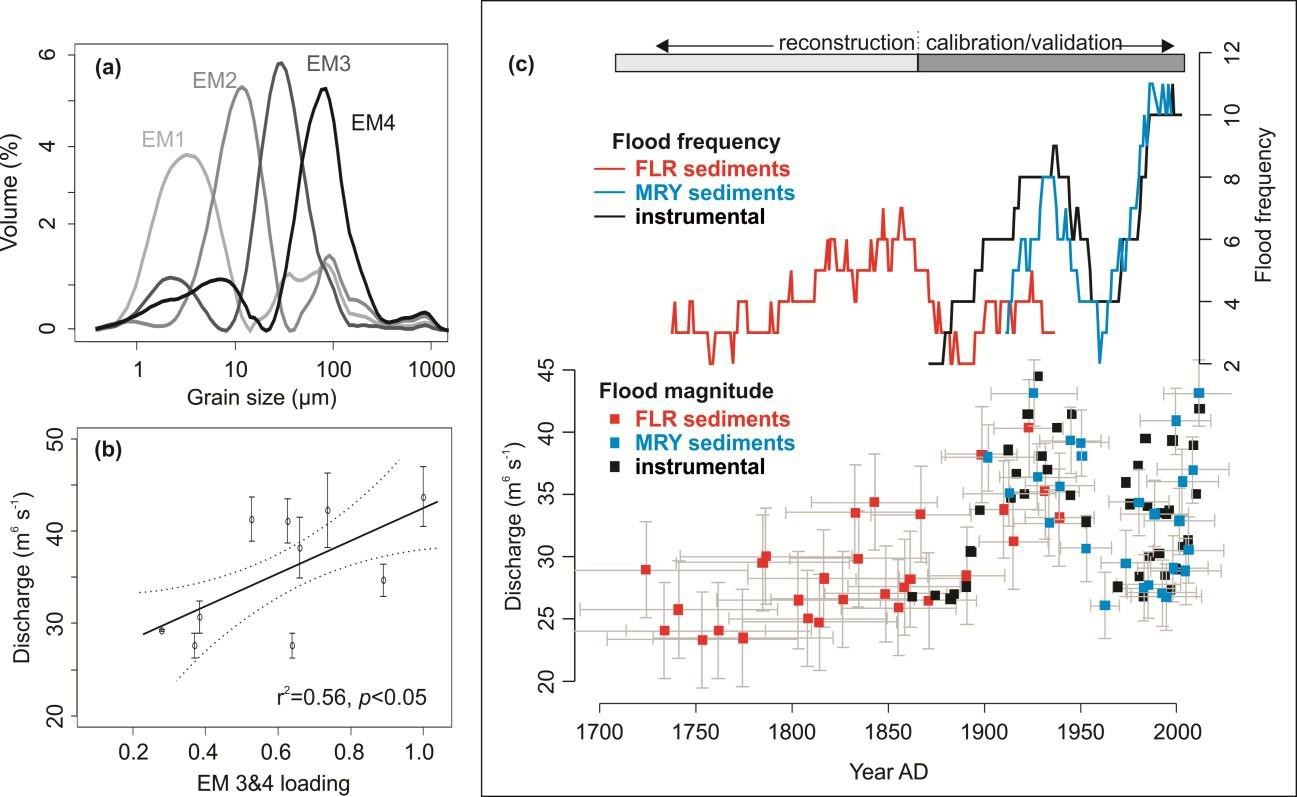
Figure 1. An example from Munoz et al., 2018 of a reconstruction of flood frequency and magnitude from sediments in the Mississippi River floodplain (False River Lake (FLR) and Lake Mary (MRY), oxbow lakes near Baton Rouge, Louisiana): (a) Four end-members obtained by decomposing continuous grain-size measurements on FLR; (b) Linear regression of coarse end-member loading from FLR versus discharge from the gauging station at Baton Rouge for historical floods; (c) instrumental and reconstructed overbank flood magnitude (bottom) and 30-yr flood frequency (top).
We will use elemental analysis via X-ray fluorescence spectroscopy together with the radiogenic isotope ratios of strontium (87Sr/86Sr), neodymium (143Nd/144Nd), and lead (206Pb/204Pb; 208Pb/204Pb) of floodwater deposits to establish flood provenance. To relate the geochemical signature of floodwater deposits to their origin within the basin, we will first measure the elemental composition and isotopic ratios of additional sediment samples collected from the floodplains of the rivers Jiu, Olt, Arges, Siret, Prut and Lower Danube Rivers. We will measure early 20th century sediment samples, dated using 210Pb profiles, to avoid changes in the geochemical and isotopic signatures of flood sediments resulting from the establishment of dams. With the resulting dataset of regional sediment geochemistry, we will construct mixing-models that will allow us to evaluate the relative contributions of various tributaries to floodwater deposits in our sediment cores. For isotopic measurements in the lake sediment cores, we will focus our analyses on the fine (suspended load) component in a selected number of extreme floods, as trace elements are found in higher concentrations on finer sediments and because the suspended load reflects long-distance transport of sediment.
Interpretation will be guided by two questions: (1) How well do hydrological extremes reproduce observed trends and variability in flood frequency and magnitude on the Danube River and its tributaries in relation to climate variability? (2) What are the regional and hemispheric ocean-atmosphere circulation patterns that are associated with hydrological extremes?